December 16, 2022
In the second installment of The Land series, we charted what we believe was Chester Dickinson’s journey from Amherst, MA and arrival in Cook County and were able to answer the first three questions, in grey, listed below. Now I’m going to tackle the questions in blue.
- Why did Chester Dickinson leave Amherst, MA and come to Cook County?
- How did Chester get here? What was the journey like?
- Why did he settle in Jefferson?
- Who did he buy the land from? How did he know who owned it?
- Where did he go to buy the land?
- How much did the land cost and how could Chester afford it?
- Are original land records readily available somewhere? Where?
Most of the history books and articles out there (including Alida’s Memoir) consistently report that Chester Dickinson bought his land from E.B. Sutherland, including the Inn/Tavern that Sutherland built — which then became known as the Dickinson Tavern, on what eventually became Milwaukee Avenue. The stated years that these events took place vary somewhat, but not significantly. It would be nice to pin down accurate dates though. And, because I am fascinated with finding the actual documentation for these events, I figured it would be a relatively straightforward, painless process to find the record of Chester’s purchase from E.B., once I could figure out where these property records are.
I was wrong. It was not straightforward and painless.
Unexpected twists and turns
So, where to start? Well, Chester’s purchase from E.B. was clearly a private land sale – not the purchase of public land from the federal government. But, it dawned on me that someone was the original purchaser of the public land – probably E.B. Sutherland in 1841 when he first settled in the area, so I decided to try to locate E.B.’s land purchase first. Wouldn’t it be nice to verify who the original owner was of the land we now occupy? I quickly found search tools on the US Bureau of Land Management website, and, as long as you know the township and range (which, as you know from The Land-Part I, I do), you can find a listing of all of the public land purchases for each section in a township, including copies of the original “patents”, as the deeds/proof of purchase are called – signed by the President of the United States.
Unless you are interested in Section 16, where we live.
The Challenge of Section 16
Now what on earth? Every section is listed on the BLM search results, except Section 16. I checked other townships just to make sure our township wasn’t some kind of anomaly. Nope. Section 16 is conspicuously absent everywhere. What is up with Section 16? Oh dear, new research required – which, as it turns out – was not so easy. But I did eventually find some stuff, and here’s the poop, as I understand it, about Section 16:
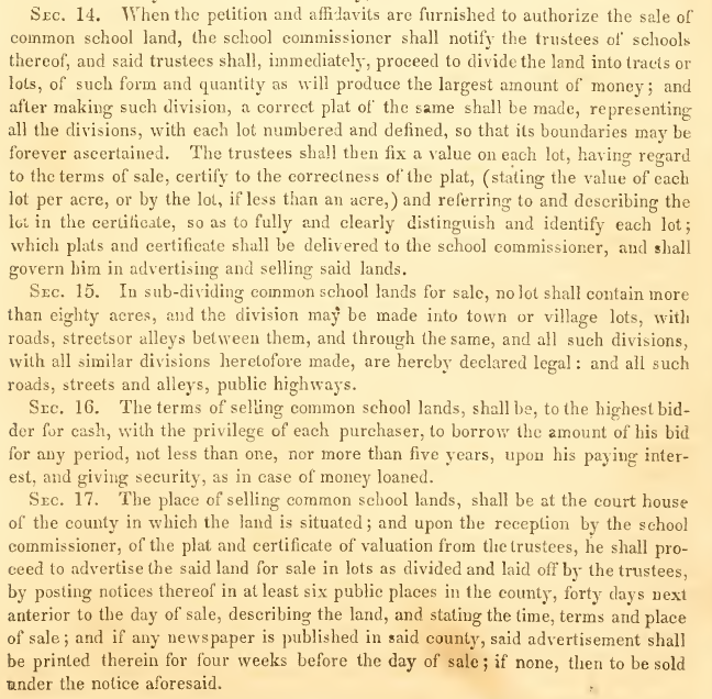
According to the Land Ordinance of 1785, Section 16 in every township was to be reserved for the maintenance of schools. Rather vague, isn’t it? That’s all I could find at first, but after copious digging, I pieced together some bits, and my understanding now is: The federal government donated the Section 16 land in every township to the States. Each state, then, established their own laws related to the administration of these school lands in Section 16. The elected state school commissioners/trustees set the prices for the land, administered the purchase, and used the income from the land sales for the maintenance of schools throughout the township/county. Since the land purchases were made at the state level, they were not recorded by the feds, nor were federal patents issued. Then where are Section 16 records? I sent several inquiries to BLM but, let’s just say, I was “dismissed”. Disappointing.
The next Challenge – Old Private Property Records
Well, so much for finding the original owner. I figured I should just focus on finding the records for the private land sale between E.B. (Elias Bliss) and Chester. Where might those be? Could they be at the County Clerk’s office? Is there some kind of Archive office there? It sure seems like that would be the logical place but I never saw evidence of anything like that. So I sent an email inquiry to the top dog, Karen Yarbrough, County Clerk (why not?). I did receive a response (not from Karen) and then provided a subsequent detailed response of what I was looking for. This is the next reply I received:
“So are recorded only goes back to 1871 I would suggest you go to Chicago title there recorders I believe goes back further than yours I might be able to help you”
I was not sure that I could decode the message above correctly, so I asked again who I should specifically contact and the reply was two words: “Chicago title“. All rightee then. Confused. But then it dawned on me – 1871 – The Great Chicago Fire. That makes sense. Property records prior to 1871 were probably destroyed. So, does the clue “Chicago title” mean Chicago Title Insurance Co.? Why would a commercial company have those records? Well, thank goodness for the collective knowledge of our neighbors: I was telling Zia Sargis from the 5100 Berteau block, who is a real estate agent, about this and he said he heard all about the relationship between the Chicago Fire and Chicago Title at a real estate seminar. I poked around on Chicago Title’s website and found the whole story, which you can read, at your convenience: Chicago Title Insurance Company History or Chicago Title and Trust (chicagohistory.org). Very interesting.
Now a new problem – finding who to contact at Chicago Title. Try calling there and see if there is an option in the lengthy auto-attendant menu for historical records. I tried – there isn’t. Instead, I asked my next-door neighbor, Jenny Snyder, if her friend at the Newberry Library could help. She did get back to me with information but it was pre-pandemic info and no longer valid. I also contacted the Chicago History Museum and they told me that the ante-fire records were recently moved to a new company called Property Insight. Property Insight responded to my inquiry, stating that a search costs $375.00 and provided a list of all the information that I would NOT receive, but did not list what I would receive. Geez! Pass.
So far, I’m not making any progress.
Fortuity
You know, you just never know.
I got a notice that my license plate sticker needed to be renewed, so I went online to the IL Secretary of State website to renew it, like I always do. While there, knowing that my senior citizen status was imminent, I wanted to find information about senior discounts, if any. While perusing all of the menu items, I noticed an unexpected but very enticing link to the Illinois State Archives and started poking around there. Hmmm. More poking and then, HOLY COW! I found a searchable database of public land sales in Illinois including — ding, ding, ding — SECTION 16!
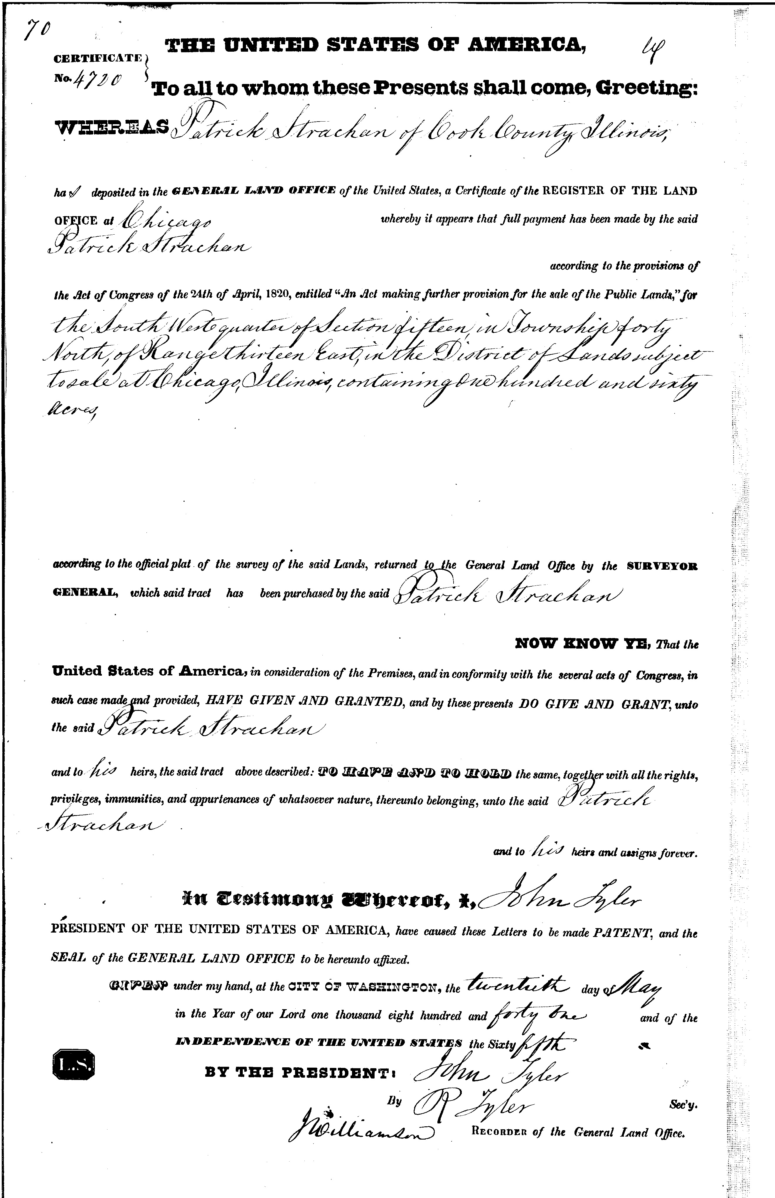
And then, something really unexpected happened — I found a record for the purchase of 40 acres of public land in Section 16 by our man, Chester Dickinson! Whoa! What! I could not believe my eyes. I have never read anywhere that Chester made 2 separate land purchases and that one purchase was public school land. That means that no one else (other than the native Americans, of course) ever owned this piece of property. In other words, no one other than the Dickinson family has ever owned the 40 acres between Belle Plaine and Berteau — until AWD started real estate development. That really is pretty rare! How cool is that?
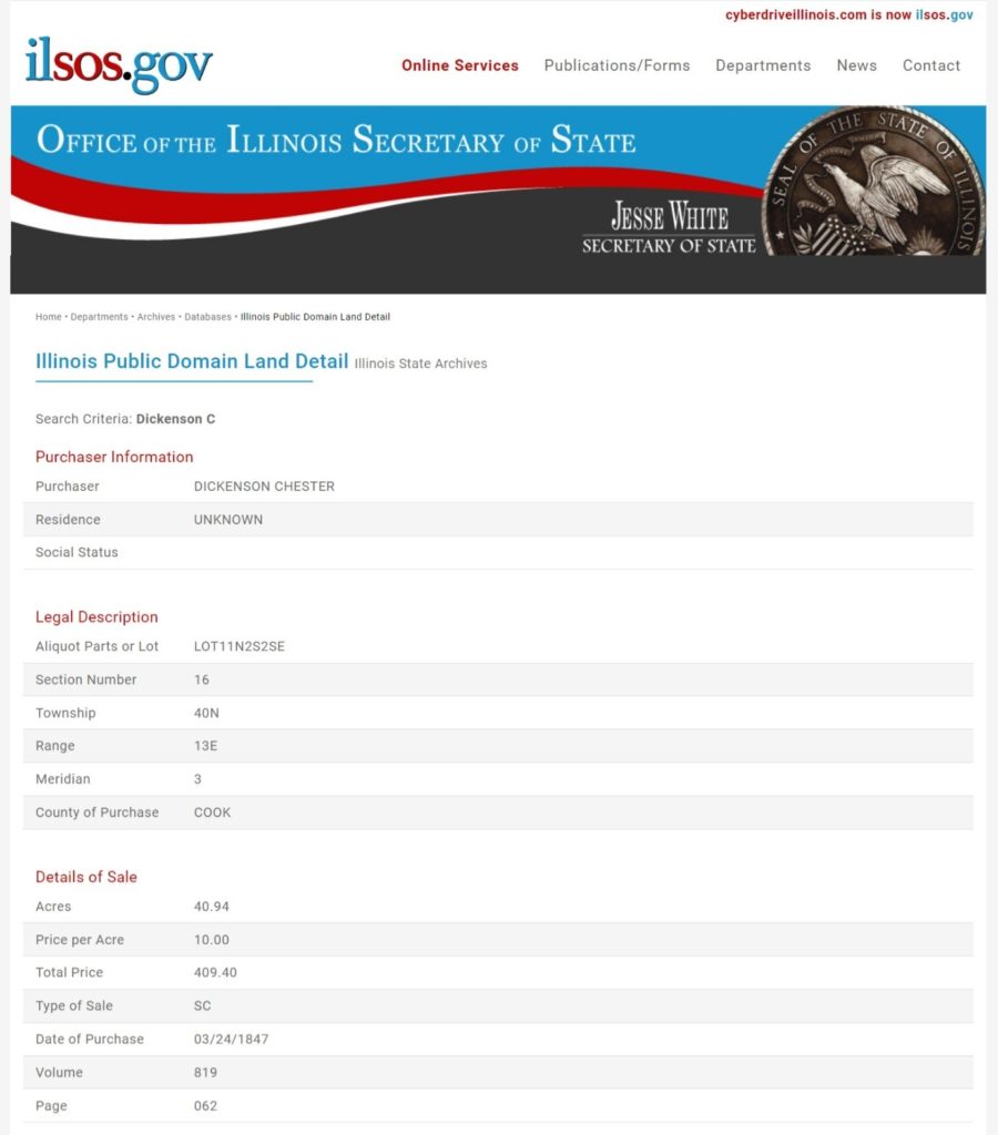
I was dying to see some form or original record of this. I was hoping that I didn’t need to drive down to Springfield, though. I sent a general inquiry to the Illinois State Archives, received a quick response, provided detail of what I was looking for, received a response the same day stating that a copy was mailed to me. I wasn’t sure what that meant but I was thrilled. And no fee required. Here is what I received:
One interesting thing (though it is all very interesting) – besides the aliquot (N2S2SE) there is also a Lot number (11) associated with the land parcel. There are no lot numbers associated with the aliquot for any non-Section 16 sections. Looks like the School Commissioners assigned Lot numbers, as well, to the legal description. This was a helpful move, as you will read later. And now, I also know what some of the other numbers mean on real estate maps, and also on property records – very important. (aliquot definition: portion of a larger whole)
how about Lot 12?
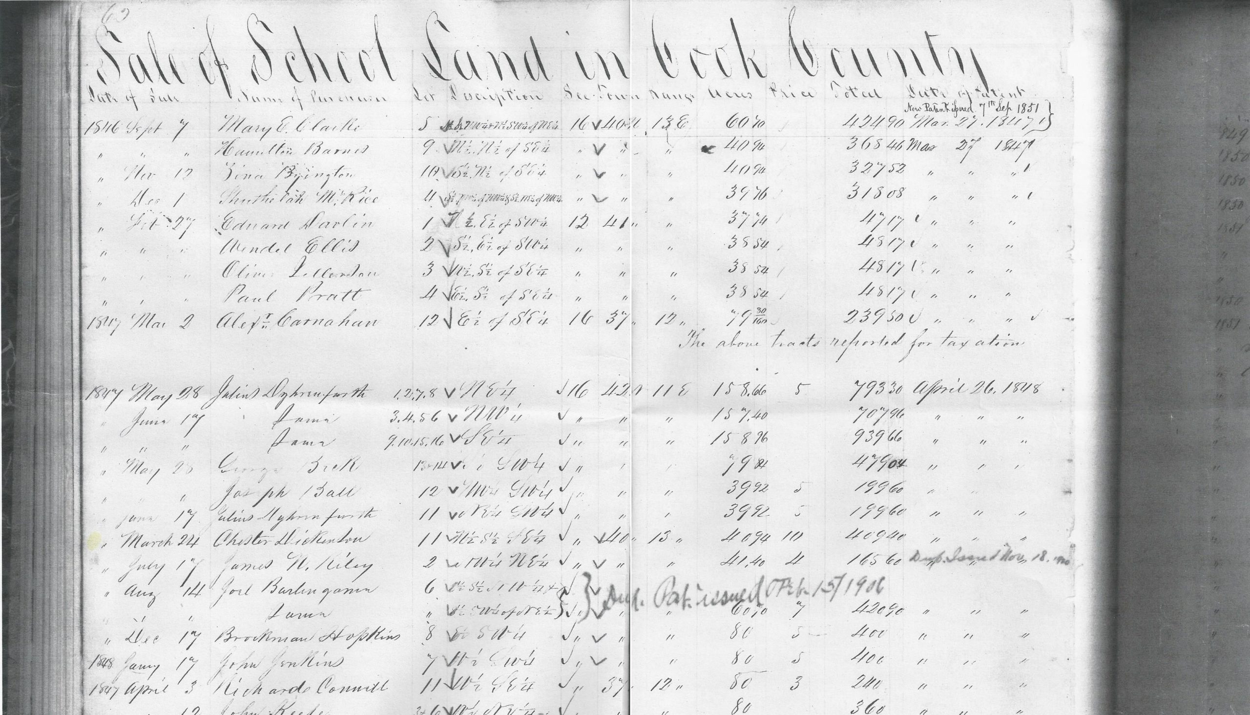
I took a different approach for the search to find Lot 12 and I got this fabulous list displaying the purchasers of each of the lots in the whole section:
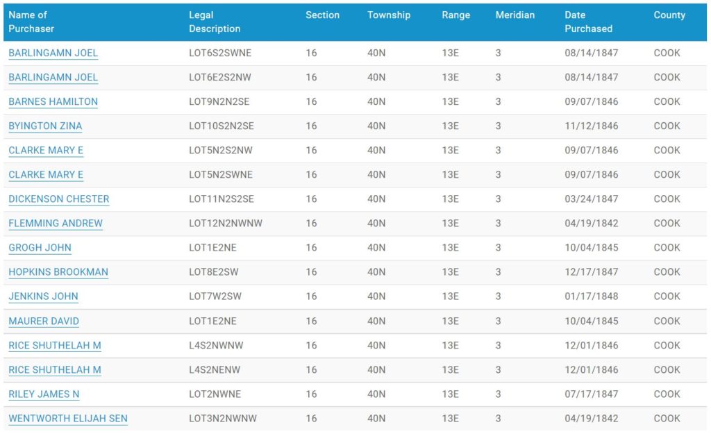
Now I had a new quandary (surprise!).
First off, you’ll notice that there is no mention of E.B. Sutherland in the list. That’s very surprising. I was convinced that he should be there and felt something was wrong. BUT – the list shows that Lot 12 was purchased by Andrew Flemming, who I have never heard of, back in 1842, one of the earliest purchases in the section. OK, everyone says E.B. bought the land and built the Tavern in 1841 and here we have someone else who bought this piece of land in 1842. How does that work?
Is there some kind of mistake? Because there is yet another issue: the aliquot, which should be S2S2SE for Lot 12, is noted as N2NWNW ???? So, which is correct – the aliquot or the Lot #, because I see that Lot 3, purchased by Wentworth, also has the same aliquot? How can that be? Oh dear, straightforward and painless? NO!
Time to write to the IL State Archives.
It can be quite difficult to articulate some questions in writing, and this certainly was one of those. At first, the response I got was that the records are correct — case closed. Not in my mind, though. Instead of trying to clarify with words, I created a diagram from the Section 16 search results. I also asked the question, “Who purchased S2S2SE, because if the records are correct, then no one did.”
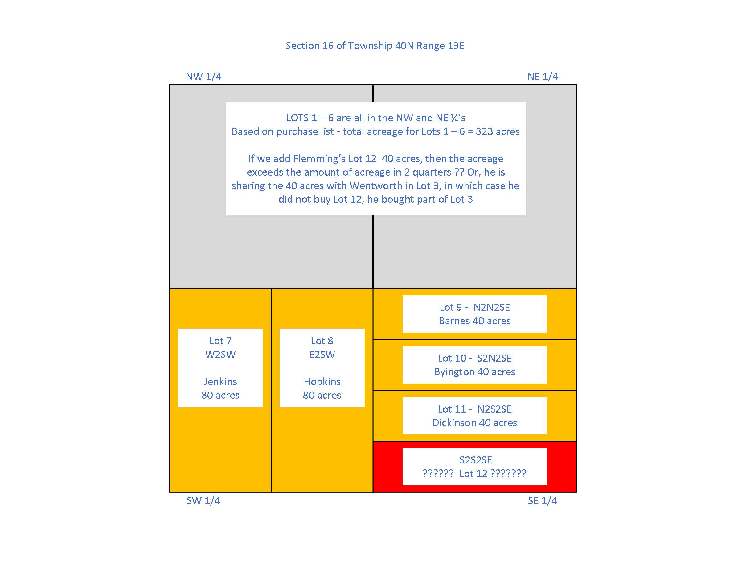
Click on image to view full size.
Based on the diagram, Jim, the guy who was helping me, conceded that something was definitely not right, but wasn’t sure what was up. He sent me the ledger page for 1842 purchases (awesome guy, by the way, really trying to help). Oh boy, I saw the issue right away.
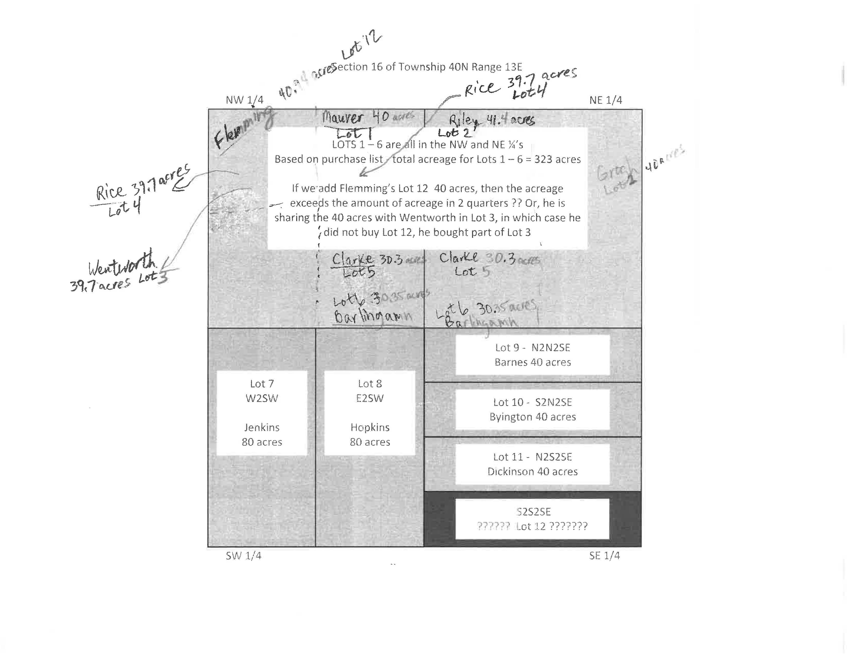
The case of the missing dittoes
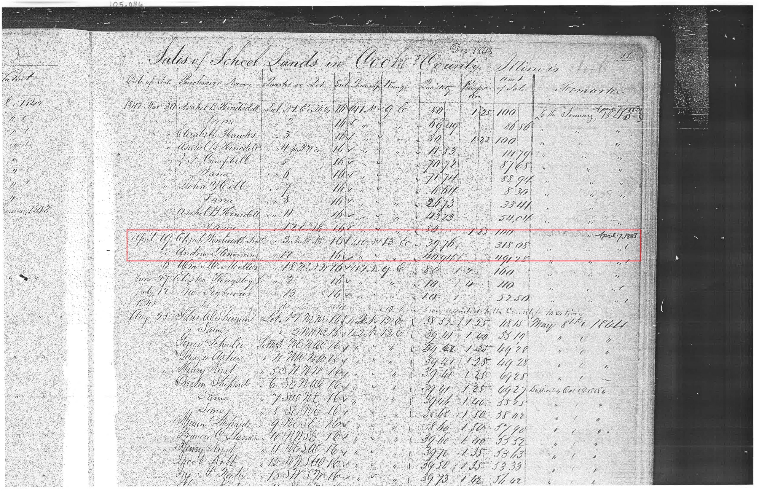
You’ll notice on this ledger page, and also the page showing Chester’s record, the use of ditto marks is quite extensive and quite deliberate. The entry for Andrew Flemming is right below Elijah Wentworth, entered on the same day. I was able, via other sources, to verify that Wentworth bought Lot 3 in the NW quarter. The entry for Flemming specifies Lot 12, but there is NO entry for the aliquot and there are NO ditto marks for the aliquot. Why the aliquot is blank is not known. There are a number of other missing aliquots and dittoes on this page (see March 30, 1842 transactions). So, my theory is that whoever did the data entry into the database for these records, assumed the ditto marks and entered the same aliquot as Wentworth’s record above.
I believe that my theory is correct and solves the mystery: Andrew Flemming (Fleming) purchased Lot12S2S2SE in 1842. This is the Lot between Irving Park and Belle Plaine, right at Six Corners, and the Lot that the Sutherland/DickinsonTavern was built on.
I did eventually find a public land purchase made by E.B. Sutherland in 1841, but it was in Section 12-42N-10E, which is the Palatine area. He bought 40 acres @ $1.25/acre. In other words, he was around in the area in 1841.
More info about section 16
Since I was interested in finding out where people went to make the land purchase, and Googling did not help, I reached out to the IL State Archives, again. They replied that they did not have the answer nor the resources to do the research, but they did send me a link to an 1845 book of Illinois statutes, and one chapter is called “Schools”. I might rename this chapter “Everything You Ever Wanted to Know about Section 16.” So many questions answered now.
Here are some relevant and informative clips from the book:
The questions
Who did Chester buy the land from? How did he know who owned it?
Chester made two separate land purchases from two different sources. The 40 acres of Lot 11 in Section 16 were purchased from the School Commissioners, in accordance with the state laws. The other 40 acres of Lot 12 in Section 16 were purchased from a private party (TBD). When Chester and Alida stayed at the Sutherland Inn on their way to Racine, WI, they received an offer from E.B. to buy the Inn and the land – See Alida’s Memoir in The Land-Part II.
Where did he go to buy the land?
Since the Lot 11 purchase was of public school land, Chester would have gone to the Cook County Courthouse – see Sec. 17 of IL Statutes above.
How much did the land cost and how could Chester afford it?
Chester purchased the 40 acres in Lot 11 for $10.00/acre. Details and costs related to Lot 12 will be shared in the next article. Per Alida’s Memoir, Chester had an inheritance of $7500.00.
It’s interesting to see that school lands were priced significantly higher than federal lands, which typically sold for $1.25/acre.
Are original land records readily available somewhere? Where?
The saga of locating early, ante-fire private land/property records will be extensively shared in the next article. “Fasten your seatbelts, it’s going to be a bumpy night. “
time for a breather
What started as “let’s do some fun, easy research” didn’t quite turn out that way, as you can see. But as a result of going down that path, I uncovered some surprising information that has gone against the common lore. Rather than just reporting my findings, I felt it was important for you to understand how this information was uncovered and to share the evidence.
The new really big question is:
How could E.B. Sutherland build the Inn on land he did not own?
Hang tight – I found the answer.
As always, a bit of scandal
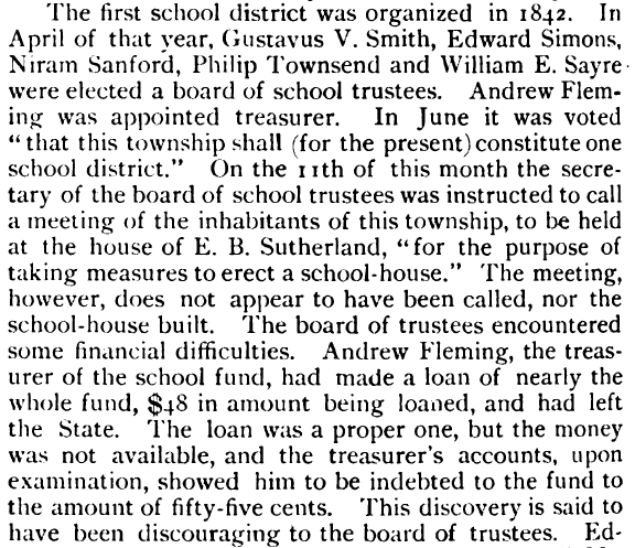
Turns out that Mr. Andrew Fleming did not stick around town very long. I stumbled across this clip in The History of Cook County Illinois, From the Earliest Period to the Present Time” by A.T. Andreas, 1884 in the chapter “History of Jefferson”:
Never a dull moment!
This is all crazy and anyone else would have given up as this required a trip (many trips) down the rabbit hole.
But you’ve gotten there and now have really good proof of what’s happened!
Nice work!
Very interesting! Hope you have a wonderful Christmas.
Wow,You are a sleuth!!
Hi Ruta,
Wonderful article! Your writing, research skills, and tenacity are just amazing!